About the Project
The Woodstock Layover Yard relocation and expansion project aims to improve operational efficiency and maximize safety, security, and personnel time.
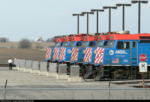
The Woodstock Layover Yard project would consolidate operations across multiple existing yard locations to a larger, cleaning and light maintenance facility near Woodstock, Illinois.
This new facility will include the following:
-
Seven storage tracks to accommodate 14 trains
-
Two equipment storage tracks
-
An 8,700 square foot maintenance and crew building with two garages
-
Power feeds to supply all storage tracks and generator for emergency power
-
A 45,000-gallon above-ground diesel storage tank for locomotive fueling
-
Three driveways, access roads, and at least 80 employee and visitor parking spaces
-
Miscellaneous facilities such as material storage, waste disposal, high-mast light towers, security fencing, security system and a communications tower
Goals & Benefits
The overall goal of the Woodstock Layover Yard Project is be more efficient and support anticipated ridership growth along the UP-NW line.
Goals & Objectives
Beyond meeting current and future demand, the new Woodstock Yard is intended to expand train storage, improve operational efficiencies, maximize safety and security, and promote sustainable travel patterns in McHenry County.
Project Benefits
-
Increased commuter rail service
-
Operational cost savings
-
Job opportunities at the layover yard
-
Reduced train idling at Crystal Lake Station
-
Opportunity for future development in station areas
-
Shift commuting patterns from car to commuter rail
? More Tracks = More Trips
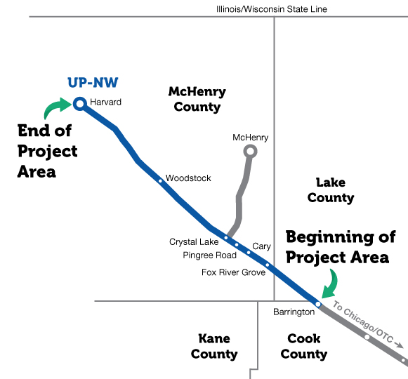
The UP-Northwest line is the second busiest across the Metra system! Unfortunately, the capacity of the UP-NW line is heavily constrained by the current infrastructure.

Additional trains and train storage are essential to meet the growing demand.
In the proposed plan, the seven new storage tracks will allow for up to 21 additional trips during weekday service.
Proposed Sites
The process of identifying a new rail yard location began with an analysis by our project team of 12 potential sites along the UP-Northwest line, including an evaluation of expansion potential at existing yards.
Preliminary Site Criteria
- Location
- Adequate space
- Meets goals and objectives
Preferred Area
The preferred location is within five miles of the Woodstock Station.
Screening Process
Our team implemented a screening process and scoring criteria that evaluated each site on factors including current and future land use, available acreage, environmental considerations, and geographic locations best suited to meet future ridership growth.
1. Identification of Initial Site Alternatives
- Wide range of potential locations
2. Preliminary Screening of Initial Site Alternatives
- 12 sites identified
- Preliminary Screening Criteria:
- Location of site
- Available area
- Meets goals and objectives of project
3. Detailed Screening of Remaining Site Alternatives
- 10 sites eliminated that did not meet Preliminary Screening Criteria
- Detailed Screening Criteria:
- Right of Way Needs
- Civil Design/Construction Complexity
- Railroad and Roadway Operations
- Environmental Considerations
- Socioeconomic Impacts including Title VI Equity considerations
- Cost
4. Recommended Site Alternatives
- 2 sites selected for detailed analysis
- Public input
- Additional analysis
Screen Results
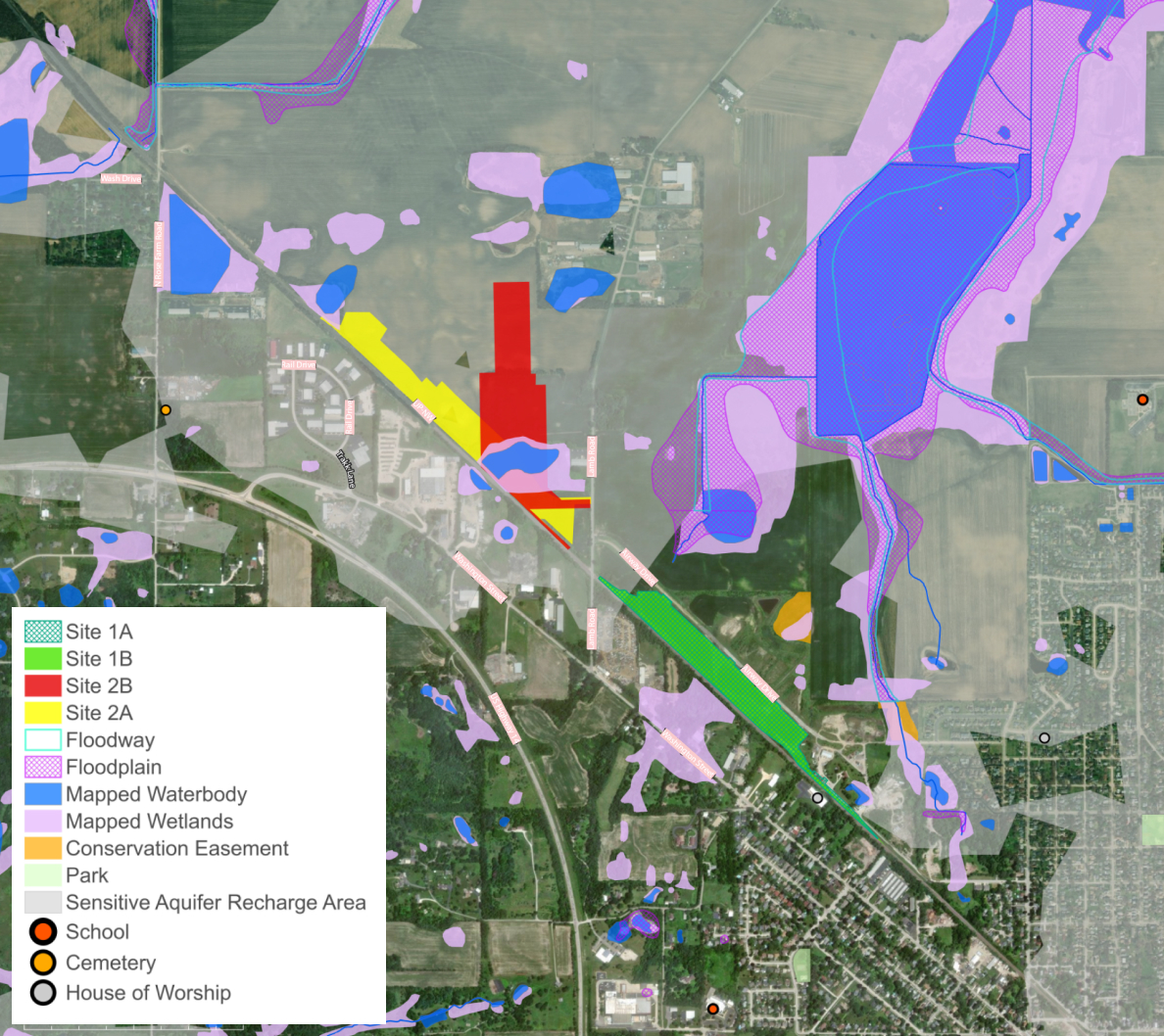
Only two recommended site locations emerged from our project team’s screening process. Our team assigned positive, neutral, or non-preferred rankings for each scoring criterion to each site under consideration. These two sites, near the City of Woodstock, scored the highest positive rankings through the scoring matrix and are recommended as those best able to meet the project goals and objectives and achieve benefits for the community
| Screening Criteria | Site 1A – MP 52.8 East of Lamb Road |
Site 1B – MP 52.8 East of Lamb Road |
Site 2A – MP 54.1 West of Lamb Road |
Site 2B – MP 54.1 Northwest of Lamb Road |
|
|---|---|---|---|---|---|
| ROW Needed |
Acres, Right-of-Way (ROW) | Positive |
Positive |
Positive |
Positive |
| Demolition Required | Neutral |
Positive |
Positive |
Positive |
|
| Construction Complexity |
Utility Relocations | Neutral |
Neutral |
Positive |
Positive |
| Proximity to Existing Utilities | Positive |
Positive |
Neutral |
Neutral |
|
| Existing Construction Access | Positive |
Positive |
Neutral |
Neutral |
|
| Railroad and Roadway Operations |
Rail Yard Access | Positive |
Positive |
Positive |
Neutral |
| Facility Circulation | Positive |
Positive |
Neutral |
Neutral |
|
| Freight Interference | Positive |
Positive |
Positive |
Positive |
|
| Sufficient Space for Drainage Detention | Positive |
Positive |
Positive |
Positive |
|
| Minimize Earthwork | Neutral |
Neutral |
Positive |
Positive |
|
| Yard Tracks, Lead Tracks | Neutral |
Neutral |
Positive |
Negative |
|
| Grade Crossing Closures or Additions | Positive |
Positive |
Positive |
Positive |
|
| Proximity to Existing UP Control Point or Crossover | Positive |
Positive |
Positive |
Positive |
|
| Capacity for Train Storage Needs and Operations | Positive |
Positive |
Positive |
Neutral |
|
| Safety and Security (Emergency Access) | Positive |
Positive |
Neutral |
Neutral |
|
| Environmental Considerations |
Mapped Wetlands (in acres) | Positive |
Positive |
Negative |
Negative |
| Potential for Unmapped Wetlands and Waters of the U.S. | Neutral |
Neutral |
Neutral |
Neutral |
|
| Noise Sensitive Receptors | Neutral |
Neutral |
Positive |
Positive |
|
| Known Cultural Resources within Site | Positive |
Positive |
Positive |
Positive |
|
| Prime and Unique Farmland (in acres) | Positive |
Positive |
Neutral |
Neutral |
|
| Critical Habitat and/or Sensitive Biological Areas | Neutral |
Neutral |
Negative |
Negative |
|
| Special Waste | Positive |
Positive |
Positive |
Positive |
|
| Consistent with Land Use | Positive |
Positive |
Neutral |
Neutral |
|
| Socioeconomic Impacts including Title VI Equity Impacts | Positive |
Positive |
Positive |
Positive |
|
- Positive
- Neutral
- Not Preferred
Environmental Considerations
Environmental considerations are key to our project team’s site evaluation criteria. For the remaining two reviewed sites, our team considered potential impacts to wetlands, wildlife, cultural resources, and community impacts, such as noise and light.
Optimal Site Characteristics
- Minimal wetlands
- Absence of critical habitat for protected species
- Compatibility with existing and future land uses and zoning
- No conflicts with Special AquiferRecharge Areas
- Minimal hazardous waste concerns
- No known cultural resources
- Minimal impact to surrounding community, including noise, light, glare
Recommended Site Alternatives
Throughout the site screening process, we identified two recommended sites near the City of Woodstock. These two sites received the most positive rankings during our screening. We will continue to evaluate and gather public input on these options.
East of Lamb Road
Pros:
- Adequate footprint available for desired train storage
- Adjacent to planned and partially constructed roadway for ease of access
- Adjacent to planned and partially constructed utilities in Airway Drive anticipated to be complete prior to Metra project construction
- Subdivided site allows property acquisitions of undeveloped lots with minimal impact to adjacent properties
Cons:
- Potential need to relocate 4 garage buildings
- Impacts prime farmland
- Extensive off-site fill required
- Potential impacts to stream and habitat within yard footprint
- Site geometry requires yard tracks on a slight grade
West of Lamb Road
Pros:
- Adequate footprint available for desired train storage
- Significant portion of site area within existing Metra Right-of-Way
- Limited grading and off-site fill required
- Less constrained by adjacent properties, allows improved track geometry and flatter storage yard.
Cons:
- Larger site footprint required to add roadway and utility access from Lamb Road
- Impacts prime farmland
- Impacts wetland and potential habitat
- Located entirely within Sensitive Aquifer Recharge Area
Next Steps
As the project moves forward, the next steps include a National Environmental Policy Act (NEPA) study, traffic analysis, and collecting your input to select and develop a preferred alternative. These next steps of the project, considered Phase I, will continue through early to mid-2025.
Phase 1 | 2023 - 2025
Preliminary Engineering, NEPA, and Environmental Services
Conceptual Engineering (10%) and Alternatives Analysis
- Schematic site assessments
- Develop and analyze initial alternatives
- Conceptual yard layouts
Public Meeting #1
Environmental Studies and Assessment
- Draft environmental document
- Traffic analysis
- Select preferred alternative
Public Meeting #2
Preliminary Engineering (30%)
- Final environmental document
- Use public feedback to inform preferred alternative
- Develop preferred alternative
Public Meeting #3
Phase 2 | 2025 - 2027
Final Design and Land Acquisition
Phase 3 | 2028 - 2030
Construction


